 RondoTrace
Which supply chain risks satellite monitoring can detect, and which it cannot
Last updated:
In short
Satellite monitoring can detect physical changes at a site: forest loss, new building, furnaces going cold, a site turning dim at night, changes in air quality, wet area on a tailings facility and movement of an embankment. It cannot see inside buildings, workers, contracts or finances. RondoTrace reports the first group and says where a measure is weak.
What can and cannot be detected
A risk can be detected from orbit when it changes something physical that is large enough to measure and can be compared with earlier readings.
| What you want to know | From orbit | Note |
|---|---|---|
| Forest cleared in a sourcing area | Yes | Dated by period. Not who cleared it. |
| A plant being built or extended | Yes | Built area and light at night. Not how complete it is inside. |
| A furnace or flare running | Yes | Heat by month. Cloud removes some readings. |
| A site going idle | Often | A dim or cold site shows when, not why. |
| Air quality around a site | Yes | Compared with the surrounding area. |
| Wet area on a tailings facility | At most sites | An area, not a volume of water. |
| Movement of a dam embankment | At chosen points | Not the whole structure. |
| Working conditions and wages | No | People are not visible. |
| Output inside a building | No | Roofs hide it. |
| Contracts, ownership and finances | No | These need records. |
| When an incident will happen | No | We do not predict incidents. |
How we decide whether a measure works at a site
Before we report a measure at a site, we check whether it could show a change there at all. We compare the site with its own earlier years and with its surroundings, and we look at how often cloud removes a reading. Where the answer is poor, the measure is marked weak on the page, and we do not treat a quiet result as good news.
A worked example: a measure that does not work
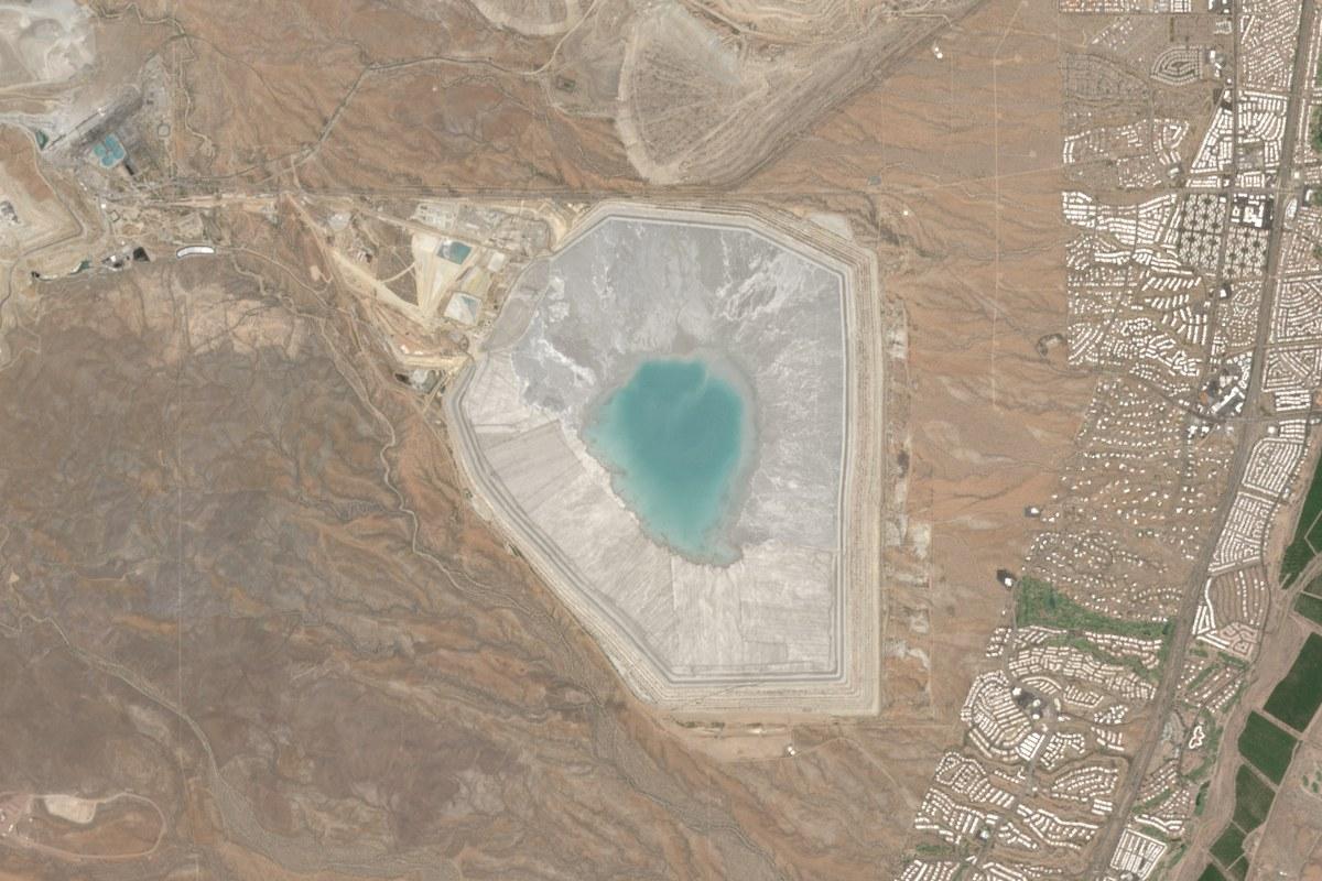
The Sierrita tailings facility in the United States is in our Outlook tool for regulators. Our wet-area figure there has stayed between 173 and 178 hectares for two and a half years. That looks reassuring, and it should not be read that way. The area we measure at this site is wet in every period, so the figure would read the same even if the pond changed, and it would not show wet ground forming outside that area. In the images the pond looks larger in June 2026 than in June 2021.
We publish the site with the measure marked weak, and with the advice not to take a quiet result as proof that all is well.
Limits
Cloud and tree cover hide the ground. Sites in the far north have no brightness reading in summer, because it does not get dark. A measure that works at one site can fail at the next. Evidence from orbit shows that something changed and does not show who caused it. We do not predict incidents, and we do not say how likely one is.
Who uses this and for what
- Buyers comparing monitoring providers use this list to check what they are being offered.
- Due diligence teams use it to decide which questions go to satellite monitoring and which go to audits and records.
- Regulators and insurers use it to judge how much weight a quiet reading can carry.
Questions buyers ask
Can satellites detect forced labour or child labour?
No. Satellites can show a camp or a clearing. They cannot show who works there or under what terms, so claims of this kind need evidence from the ground.
Can you see through cloud?
Radar can, and we use it for ground movement. Optical images, heat and brightness readings are lost on cloudy days, so some sites have gaps in some months.
Can you tell who caused a change?
No. We can show that forest was cleared or that a pond grew, and when. Finding out who was responsible takes ownership records, permits or a visit.
Can satellite monitoring warn of a dam failure?
We do not predict failures. We measure movement at chosen points on an embankment and wet area on the facility, and we report when either departs from its own record. What that means for safety is for the engineer responsible for the dam.
You can try this on real sites in the Outlook tool, ask for a first reading of a site of your own at Check a site, or read Tailings dam monitoring by satellite.